|
|
Climate and Migration, Managed Retreat, and Data Best Practices Discussed by CIESIN Scientists
|
|
December 21, 2020
Associate director for Science Applications Alex de Sherbinin gave a talk December 18 on the intersection of climate change impacts and migration to the Uncommon Schools, a network of charter schools serving minority students in New York City. Earlier in the month, he also served on a panel, “In Crowding Climate Danger Zones, Seeking Paths to Managed Retreat,” held December 16 as part of the Sustain What? Webcast series. The panel, moderated by journalist Andrew Revkin, founding director of the Earth Institute's Initiative on Communication and Sustainability, also included colleagues Lisa Dale and Radley Horton, who with de Sherbinin are on the organizing committee for an upcoming 2021 conference on managed retreat. Senior digital archivist Robert Downs recently posted a blog entry for the World Data System (WDS) of the International Science Council (ISC) on data citation practices. The December 15 post summarizes an opinion piece published November 16 in EOS, with lead author Suresh Vannan and co-authors Walt Meier, Bruce Wilson, and Irina Gerasimov. The article argues that concerted efforts by the research community are needed to expand appropriate citation of data sets, in order to improve the provenance and reproducibility of research and thereby its credibility and value. In another WDS blog post, released December 4, de Sherbinin discusses current data practices in citizen science, based on an article co-authored with lead author Anne Bowser of the Wilson Center that was recently published in the journal Citizen Science: Theory and Practice. Improving data management practices in citizen science is critical to ensuring that these efforts produce useful data for scientific research or policy applications. The article was an output of a joint Task Group on the Validation, Curation, and Management of Citizen Science and Crowdsourced Data established by the ISC Committee on Data (CODATA) and the WDS, which de Sherbinin co-chaired. He is also the current chair of the WDS Scientific Committee and a co-chair of a new CODATA-WDS Task Group, “Citizen Science for the SDGs.”
See: “In Crowding Climate Danger Zones, Seeking Paths to Managed Retreat” (“Sustain What?” Webcast)
“Promoting Proper Data Citation Practices” (World Data System Blog)
“Current Data Practices in Citizen Science” (World Data System Blog)
|
|
Global Earth Science Community Connects Online for Annual Meeting
|
|
December 18, 2020
An online version of the annual American Geophysical Union (AGU) Fall Meeting brought together nearly 29,000 scientists and other experts for more than two weeks of online presentations, sessions, and exhibits December 1–17. CIESIN experts organized or co-chaired seven sessions and presented or co-authored twelve invited, oral, e-lightning, and poster papers, on a range of topics in multiple AGU tracks, including Global Change, Natural Hazards, Earth and Space Science Informatics, and Science and Society. Oral sessions included pre-recorded video talks of up to 15 minutes, combined with a one-hour live session with five-minute summaries and a moderated discussion. E-lightning sessions combined an online, interactive “iposter” with a one-hour live session with three-minute summaries and a discussion period. Posters consisted of an iposter made available for 24 hours within a designated visit period. This unique format enabled participation by scientists all over the world, albeit often at unusual hours of the day or night depending on time zones. Alex de Sherbinin, associate director for Science Applications, presented an e-lightning paper on the Global COVID-19 Viewer, a mapping tool for data related to the coronovirus pandemic developed by the NASA Socioeconomic Data and Applications Center (SEDAC). Senior digital archivist Robert Downs gave two different e-lightning talks: “A Data Lifecycle Approach to Enabling Use by Capturing Data Provenance and Attribution” and “Advancing Open Data Sharing Across the Earth, Social, and Health Sciences for Pressing Societal Challenges.” CIESIN director Robert Chen presented the e-lightning paper, “Why People Matter: Better Data on Population and Infrastructure to Assess SDG Progress.” Cascade Tuholske, an Earth Institute Postdoctoral Fellow hosted by CIESIN, gave an oral paper, “Global Urban Population Exposure to Extreme Heat,” and an e-lightning presentation, “A Comparison of Gridded Population Data Products in Disaster Response.” Another CIESIN postdoctoral research scientist, Carolynne Hultquist, gave an oral presentation, “Developing Flood Risk Maps for Multi-Level Humanitarian Decision Making.” Many CIESIN staff members were also co-authors on numerous papers given by colleagues from the Earth Institute or external partners such as the Earth Science Information Partners (ESIP), the German Climate Computing Centre (DKRZ), ImageCat Inc., ISciences LLC, and the United Nations Sustainable Development Solutions Network (SDSN). Chen, de Sherbinin, and Downs also convened and/or co-chaired multiple sessions on topics such as environmental intelligence, remote sensing applications in disaster management, trustworthy digital repositories, and open data sharing. Although the AGU′s online format limited the extent of informal networking and scientific discussion normally possible with an in-person conference, it did seem to allow wider participation from those who might otherwise not be able to attend, and generated a valuable set of prerecorded presentations and online posters that can be made available to a wider audience.
See: 2020 Fall American Geophysical Union Meeting
APPENDIX: 2020 Fall AGU Meeting Sessions, Papers, and Presentations with CIESIN Staff Participation (157 KB PDF)
|
|
Virtual Conferences Expand Opportunities for International Discussion and Outreach
|
|
December 8, 2020
Due to the ongoing pandemic, many international conferences have shifted to online, virtual platforms in 2020, opening up opportunities for CIESIN staff to interact remotely with new communities and showcase recent work and new resources. For example, associate director for Science Applications Alex de Sherbinin recently gave a remote keynote address, “Groundswell Model Results for South Asia,” November 25 at the International Conference on Building Resilient and Sustainable Societies, organized by Jamia Millia Islamia University in New Delhi. The address discussed ongoing work with the World Bank to model how climate impacts may induce migration out to 2050. He and research scientist Susana Adamo also participated in the virtual meeting of the Platform for Disaster Displacement’s Data and Knowledge Working Group November 24, where they gave the respective presentations, “Novel and Big Data Approaches to Identifying Disaster Displacement,” and “Migration, the COVID-19 Pandemic, and Climate in Central America’s Northern Triangle.” During the International CODATA FAIR Convergence Symposium 2020 held virtually November 27–December 4, CIESIN director Robert Chen presented in a panel session, “Synergies between Citizen Science Data and the UN Sustainable Development Goal (SDG) Indicators,” organized by Dilek Fraisl of the International Institute for Applied Systems Analysis (IIASA) in Austria. Chen then led a breakout group within this session. Alex de Sherbinin also contributed to the session, “Citizen Science in Africa for the SDGs,” giving closing remarks. The Symposium was organized by the Committee on Data (CODATA) of the International Science Council and the GO FAIR initiative. On December 1 Chen gave a short presentation, “Open Data Sharing Across the Disaster Lifecycle," in the community session, "A Call to Action for Resilience: Moving from Research to Practice,” held as part of the World Bank’s 2020 Understanding Risk Forum (UR2020) December 1–3. The session was organized by Charles Huyck of ImageCat, Inc. and Shanna McClain of NASA. Chen highlighted the importance of open data access and reuse throughout the disaster management lifecycle, not just in the immediate aftermath of an extreme event.
See: International FAIR Convergence Symposium 2020
World Bank’s 2020 Understanding Risk Forum (UR2020)
Platform for Disaster Displacement’s Data and Knowledge Working Group Virtual Meeting
|
|
Recent Job Transitions at CIESIN
|
|
December 7, 2020
CIESIN recently welcomed two new staff members, Sean Hanford and James Gibson. Hanford has joined CIESIN’s Information Technology Division as a programmer/Web developer, where he is helping to create Web sites for multiple projects, including the NASA Socioeconomic Data and Applications Center (SEDAC). A veteran of the U.S. Navy, Hanford has more than 20 years’ experience in programming and Web development with companies around the U.S. Gibson has joined CIESIN's Geospatial Applications Division as a research staff assistant, working in part on a NASA-funded grant on the use of human settlement and population data in assessing progress towards the Sustainable Development Goals (SDGs). Gibson graduated from a five-year dual-degree program in which he earned a BA in biology from Vassar College and a BE in environmental engineering from Dartmouth College. Anela Layugan, senior research staff assistant, has departed CIESIN to join the United Nations Sustainable Development Solutions Network (SDSN) as a geographic information systems analyst. Layugan was part of the Geo-Referenced Infrastructure and Demographic Data for Development (GRID3) program. At SDSN, she is supporting the SDGs Today data portal, to which CIESIN is also contributing.
|
|
Experts from Colombia and Paraguay Participate in Workshop on Using Gridded Population Data for Sustainable Development
|
|
December 2, 2020
Professor Stefan Leyk of the University of Colorado organized and led a virtual workshop November 30, “Gridded Population Data for the Sustainable Development Goals,” for experts from Colombia's National Administrative Department of Statistics (DANE) and Paraguay's General Directorate of Statistics, Surveys, and Censuses (DGEEC). The workshop provided an overview of the development and sources of gridded population data, hands-on technical training in working with selected data, and a forum for obtaining feedback on user needs. CIESIN Director Robert Chen gave introductory remarks during the opening session, and in the final session research scientist Susana Adamo provided an update in Spanish on progress and plans for the fifth version of the Gridded Population of the World (GPW) data set. Associate director for Science Applications Alex de Sherbinin, associate director for Geospatial Applications Greg Yetman, and research staff assistant Juan Martinez also attended. The workshop was organized by Leyk and Maryam Rabiee of the Thematic Research Network on Data and Statistics (TReNDS) of the United Nations Sustainable Development Solutions Network (SDSN), under the auspices of the POPGRID Data Collaborative. Funding for the workshop was provided by Deutsche Gesellschaft für Internationale Zusammenarbeit (GIZ) GmbH. POPGRID is an initiative launched by CIESIN in 2017 to bring together both developers and users of global georeferenced population data in support of development applications. POPGRID activities and resources are supported in part by the Bill & Melinda Gates Foundation and the NASA Socioeconomic Data and Applications Center (SEDAC). Leyk is also a member of SEDAC′s User Working Group.
|
|
CIESIN Highlights the Power of Geographic Information Systems on GIS Day
|
|
November 19, 2020
CIESIN experts helped to celebrate GIS Day as part of several events held virtually on November 18. For a “Lunch and Learn” Webinar organized by NASA and Esri, Greg Yetman, associate director for Geospatial Applications, gave a 10-minute talk on how geographic information systems (GIS) facilitates the integration of socioeconomic and biophysical data to support interdisciplinary research and applications. He noted CIESIN’s long history in developing gridded population data products, extending back more than 25 years when GIS software was still in its infancy. Later in the day, CIESIN and the New York City (NYC) Geospatial Information System and Mapping Organization (GISMO) held the online event, “Discover the World Through GIS in NYC.” The event featured presentations by students and researchers from CIESIN and Columbia University, Lehman College of the City University of New York, and the New York City Housing Authority (NYCHA). Nearly 80 people from around the world learned about efforts to map the movement of refugees and COVID-19; plan for disaster housing; evaluate bike paths in the Bronx; implement interactive mapping in the NYCHA; and prioritize tiger habitats in India’s wildlife corridors. The event was hosted by senior geographic information specialist Dara Mendeloff, in coordination with senior geographic information specialist Tricia Chai-Onn. Mendeloff is a member of the Board of Directors of GISMO, a volunteer organization founded in 1990.
See: “Discover the World Through GIS in NYC” (link available through December 9)
|
|
Interactive Data Hubs Help Support Countries’ COVID-19 Responses
|
|
November 17, 2020
|
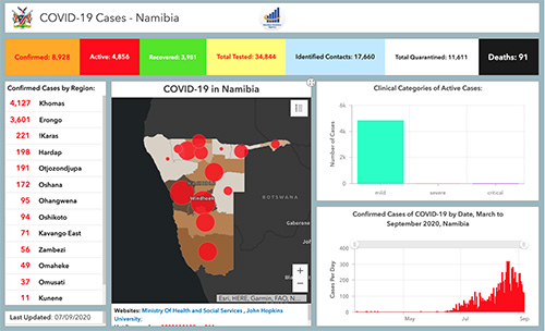
| COVID-19 data hub for Namibia. Country-specific hubs for Namibia, Nigeria, Sierra Leone, and Zambia have data on hospitals and isolation centers, population distribution in COVID-19 epicenters, and risk factors associated with COVID-19. |
Publicly accessible, user-friendly data hubs to support COVID-19 response efforts in several African countries have been developed in close partnership with national government agencies and other stakeholders. Vital components in the leveraging of these countries’ commitment and capabilities in containing the pandemic, the hubs consolidate relevant geospatial data from a variety of sources. Country-specific hubs for Namibia, Nigeria, Sierra Leone, and Zambia are currently available and include data on hospitals and isolation centers, population distribution in COVID-19 epicenters, and risk factors associated with COVID-19. The hubs also provide data visualization tools and dashboards, Web applications and interactive maps, and access to data and documentation, developed collaboratively with agencies and stakeholders. Technological support from private sector organizations Esri and Fraym was coordinated by CIESIN’s Geo-Referenced Infrastructure and Demographic Data for Development (GRID3) program. Olena Borkovska, geographic information specialist, has been coordinating technical assistance for the hub for Zambia. Other staff supporting in-country partners and stakeholders are project coordinator Justine Dowden (Namibia), senior research associate Emilie Schnarr (Nigeria), and senior research staff assistant Annie Werner (Sierra Leone).
|
|
Updates to Sustainability Indicators Released
|
|
November 16, 2020
CIESIN has recently released the preliminary 2020 version of the Natural Resource Protection and Child Health Indicators (NRPI and CHI) in support of the country selection process conducted by the Millennium Challenge Corporation (MCC). The MCC bases its selection criteria for foreign assistance on a variety of quantitative governance, social, economic, and environmental indicators, including the NRPI and CHI. The USAID has also begun utilizing the CHI in 2020 to chart progress on the Journey to Self-Reliance, an initiative that fosters sustained self-reliance on the part of developing countries. The NRPI assesses whether a country is protecting at least 17% of all of its biomes (e.g., forests, grasslands, aquatic ecosystems, and tundra). The CHI incorporates three underlying indicators—Access to At Least Basic Sanitation, Access to At Least Basic Water, and Child Mortality, ages 1–4—and serves a useful proxy for key environmental conditions. The 2020 version of the Environmental Performance Index (EPI), developed by the Yale Center for Environmental Law & Policy and CIESIN, has also been released. The EPI ranks 180 countries in two major components, environmental health and ecosystem vitality, based on 32 indicators. Produced every two years since 2006, the EPI is archived and disseminated by the NASA Socioeconomic Data and Applications Center (SEDAC) managed by CIESIN. The 2020 release includes a report, data sets for download, and an extensive map gallery of nearly 100 maps visualizing changes in performance over more than two decades.
See: 2020 Natural Resource Protection and Child Health Indicators (NRPI and CHI)
2020 Environmental Performance Index
|
|
Research Data Alliance Focuses on “Knowledge Ecology” at its Virtual 16th Plenary
|
|
November 13, 2020
Senior digital archivist Robert Downs participated in the 16th Plenary meeting of the Research Data Alliance (RDA P16) held virtually November 9–12. The meeting, which was organized by CONARE Costa Rica, RDA United States, and Research Data Canada, had the theme, “Knowledge Ecology,” focusing on how open science can support the diversification, expansion, reuse, and constant creation of knowledge, as in healthy ecological systems. On November 9, Downs led the joint breakout session of the Repository Platforms for Research Data Interest Group (IG) and the Domain Repositories IG, “Approaches for Selecting Research Data Repository Platforms and Sharing Resources to Facilitate Open Science.″ During this session, he gave two presentations, “Selecting Research Data Repository Platforms for Open Science,” and “Opportunities for Sharing Resources among Research Data Repositories.” Downs also presented the poster, “Simultaneously Leveraging Principles to Improve Capabilities for Using Research Data,” as part of the P16 poster session. Recordings from RDA P16 are now available online to meeting registrants. The RDA was established in 2013 as an international community of data experts and users. It now has more than 10,000 members from more than 145 countries.
|
|
Collaboration with Lehman College Launched to Develop Hazards Data
|
|
November 12, 2020
CIESIN has developed a collaboration with the Department of Earth, Environmental, and Geospatial Sciences at Lehman College of the City University of New York to develop and enhance hazards data, working initially with five Lehman graduate and undergraduate students. Supervised by CIESIN alumnus Yuri Gorokhovich, associate professor in the Department, the students are Christopher Aime, Diana Calderón, Nira Rahman, and Raychell Velez from Lehman's Master′s program in Geographic Information Science; and Hadja Doumbouya, a senior majoring in environmental sciences. CIESIN associate director for Geospatial Applications Greg Yetman is assisting the students in using machine learning methods to develop improved data on the exposure and vulnerability of buildings and other infrastructure to hazards, extending recent work for the State of New York supported by the New York State Energy Research and Development Authority (NYSERDA). Carolynne Hultquist, CIESIN postdoctoral research scientist, and Andrew Kruczkiewicz, senior staff associate at the International Research Institute for Climate and Society (IRI), are also working with the students to apply the data to flash flood hazard assessment. The collaboration is supported by the NASA Socioeconomic Data and Applications Center (SEDAC) as part of SEDAC's efforts to achieve small business purchasing goals established by NASA, which include collaboration with Minority Serving Institutions (MSIs) and Historically Black Colleges and Universities (HBCUs). Outputs of the collaboration will be made available via SEDAC after appropriate review. Based in the Bronx, Lehman is one of the only MSIs (or HBCU′s) in the US to offer a master of science degree in geographic information science.
|
|
Recent Webinars Highlight Tools and Data for COVID-19 and Public Health Planning
|
|
November 4, 2020
The Global COVID-19 Viewer developed by the NASA Socioeconomic Data and Applications Center (SEDAC) operated by CIESIN was the subject of the first NASA Earthdata Webinar of fiscal year 2021, “SEDAC’s Global COVID-19 Viewer: A User-Friendly Tool for Assessing National and Subnational Trends and Risk Factors in Coronavirus Spread.” The October 28 webinar was given by Alex de Sherbinin, SEDAC deputy manager and CIESIN associate director for Science Applications, and Joe Schumacher, SEDAC user services manager and CIESIN senior information specialist. Approximately 110 participants learned about the development of the Viewer, launched in March 2020 and updated most recently in September. The Webinar included a live demonstration of the Viewer, which lets users visualize spatially-explicit trends in COVID-19 infection and mortality rates, including daily updated global data on COVID-19 cases and deaths in relationship to population density and key risk factors. The demo focused on current hotspots, interesting trends, and an exploration of risk factors. On November 2, Jolynn Schmidt, program manager-data lead for the Geo-Referenced Infrastructure and Demographic Data for Development (GRID3) program managed by CIESIN, participated in a workshop at the 7th 2020 GeONG Forum, a virtual gathering of international humanitarian and development organizations. The workshop focused on different approaches and lessons learned in defining health catchment areas and assessing the number of people in them, which is important for estimating the potential number of patients and demand on health facilities. Schmidt presented her experience working to strengthen developing countries’ capabilities for mapping population distribution, human settlements, and other core spatial data layers.
See: "SEDAC’s Global COVID-19 Viewer" (Adobe Connect recording)
|
|
CIESIN Scientists Address Climate-Migration Linkages and Open Data Policies
|
|
October 23, 2020
Alex de Sherbinin, associate director for Science Applications, recently published the feature article, “Impacts of Climate Change as Drivers of Migration,” in Migration Information Source, the online journal of the Migration Policy Institute. The article reviews the growing evidence base for environmentally induced migration, summarizes key lessons learned, and assesses implications for future migration under climate change. Climate-migration linkages have also been the focus of a number of recent events. On October 21, de Sherbinin gave a presentation, “Climate Change and Its Impacts on (Well Being), Migration, and Displacement,” to the Virtual Global Climate Change Seminar Series of the Weill Cornell Medicine Global Health Education program. He also moderated a virtual panel, “Climate, Conflict, and Coronavirus: A Perfect Storm for Migrants and Displaced Persons,” October 22. Panelists included Jeffrey Schlegelmilch, director of the National Center for Disaster Preparedness; Kamal Amakrane, director in the Office of the President of the 71st Session of the United Nations General Assembly (UNGA); and Leslie Roberts, associate professor of Population and Family Health and a member of the Program on Forced Migration and Health at Columbia′s Mailman School of Public Health. This was one of a series of panels organized by the Committee on Forced Migration, an initiative of the Columbia Global Centers. CIESIN director Robert Chen presented approaches to open data access by the Earth observations and research communities during an online stakeholder consultation organized October 21 by the World Meteorological Organization (WMO). Conclusions and recommendations from the session are being submitted as inputs to the WMO Data Conference, to be held virtually November 16–19. The WMO Data Conference is seeking to develop a common understanding across all sectors of society on the roles, requirements, and arrangements needed for international exchange of observations and other data for monitoring and prediction of the Earth System environment, including weather, climate, and water.
See: “Impacts of Climate Change as Drivers of Migration” (article)
“Climate, Conflict, and Coronavirus: A Perfect Storm for Migrants and Displaced Persons” (panel)
WMO Stakeholder Consultation 2: Research data and WMO data policy (video)
WMO Stakeholder Consultation 2: Research data and WMO data policy (key messages)
|
|
United Nations Holds Virtual Forum to Promote Cooperation on Sustainable Development Data
|
|
October 23, 2020
The 2020 United Nations (UN) World Data Forum was held virtually October 19–21, in place of a physical meeting in Bern, Switzerland, that has been postponed to 2021. The Forum serves as a platform for intensifying cooperation on sustainable development data across a diverse set of communities, under the auspices of the UN Statistical Commission. Several CIESIN staff participated actively in the Forum. On October 20, Sandra Baptista, senior research associate, and Andrea Jordan, special assistant to the deputy director, both representing the Geo-Referenced Infrastructure and Demographic Data for Development (GRID3) program, co-organized the live panel, “Use of Geospatial Data to Support COVID-19 Response,” with Colombia’s National Administrative Department of Statistics (DANE). The panel was moderated by Io Blair-Freese of the Bill & Melinda Gates Foundation and included two partners in the GRID3 program: Prince Clem Ikanade Agba, minister of state for budget and national planning of the Federal Republic of Nigeria and co-chair of GRID3′s Nigeria national steering committee; and David Moinina Sengeh, minister of basic and senior secondary education and chief innovation officer for the Government of Sierra Leone. The Forum also included a number of pre-recorded sessions. NASA, UN-Habitat, the European Space Agency, and the Group on Earth Observations (GEO) organized a session on the use of Earth observations to make cities inclusive, safe, resilient, and sustainable. CIESIN Director Robert Chen co-authored a short presentation with Thomas Kemper of the European Commission′s Joint Research Centre on behalf of the GEO Human Planet Initiative, which he co-leads. They also participated in a pre-recorded question-and-answer session. Recordings of Forum sessions are now available online. The UN World Data Forum was originally established in response to a key recommendation in the 2014 report, “A World that Counts: Mobilising the Data Revolution for Sustainable Development,″ prepared by the UN Secretary-General′s Independent Expert Advisory Group on a Data Revolution for Sustainable Development.
See: “Use of Geospatial Data to Support COVID-19 Response” (panel)
“Tools to...Use Earth Observations to Deliver SDG 11 and the New Urban Agenda″ (panel)
|
|
CIESIN Supports First-Ever Virtual Lamont Open House
|
|
October 22, 2020
The free Lamont Open House has been held nearly every year since 1949, attracting thousands of students, families, and other interested individuals who live near the Lamont campus and the broader New York metropolitan area. Due to COVID-19 restrictions, the 2020 Open House shifted to a virtual format, “Lamont Open House at Home,″ held online October 19–21. Several CIESIN staff members contributed to the event, which aimed to encourage awareness and interest in the earth sciences and to emphasize how better understanding of the Earth can help preserve its future. Dara Mendeloff, senior geographic information specialist, was one of three speakers in the panel, “When am I Going to Use This? Dynamic Careers in Science,” October 19. During the panel, which was geared to students in grade 6–12, she shared her experience as a geospatial information science researcher, beginning with her early interest in environmental issues in high school and continuing with her training in and use of geographic information system (GIS) tools, data, and methods. She also highlighted a range of CIESIN mapping tools and projects and participated in the question-and-answer session. A recording of the panel is now available on YouTube. Justine Dowden, project manager with the Geo-Referenced Infrastructure and Demographic Data for Development (GRID3) program, was moderator and Emilie Schnarr, GRID3′s country manager for Nigeria, was one of two panelists for the October 20 session, “Fighting Disease with Geospatial Data and Climate Prediction.″ The session highlighted novel approaches to improve public health by using better data and forecasts to improve planning for outbreaks of mosquito-borne diseases and for vaccination campaigns that need to reach all vulnerable populations. Ángel G. Muñoz, associate research scientist at the International Research Institute for Climate and Society (IRI) was the other panelist. CIESIN staff have participated regularly in the Lamont Open House, since CIESIN′s move to the Lamont campus in 1998 to become part of the Earth Institute.
See: ″When am I Going to Use This?: Dynamic Careers in Science” (video—presentation begins at 23:45)
″Fighting Disease with Geospatial Data and Climate Prediction” (abstract)
|
|
New Data on Food Insecurity 2009–2019 and Settlement Extents in Africa Released
|
|
October 19, 2020
CIESIN has developed and released several new data sets recently. Now available from the NASA Socioeconomic Data and Applications Center (SEDAC) is the Food Insecurity Hotspots data set, which consists of gridded data identifying the level of intensity and frequency of food insecurity over ten years between 2009 and 2019, as well as hotspots of consecutive food insecurity events. The data set covers five regions: Central America and the Caribbean, Central Asia, East Africa, Southern Africa, and West Africa. The grids are at 250 meter (~7.2 arc-seconds) resolution and are based on subnational food security analyses for these regions provided by the Famine Early Warning Systems Network (FEWS NET). FEWS NET was established in 1985 by the U.S. Agency for International Development (USAID). As part of the Geo-Referenced Infrastructure and Demographic Data for Development (GRID3) program managed by CIESIN, data on operational settlement points and/or boundaries, health facilities, and points of interests have been released for Zambia and the Democratic Republic of the Congo. Settlement extent data are now available for 41 African countries, created from Digitize Africa building footprints powered by Maxar. GRID3 has expedited settlement extent mapping to support countries in their COVID-19 response efforts. The data are broadly intended to support country decision-making in public health and education.
See: Food Insecurity Hotspots Data Set, v1 (2009 – 2019)
GRID3 Data Available through Columbia Academic Commons
|
|
Members of the International Science Council World Data System Meet Virtually
|
|
October 16, 2020
The World Data System (WDS) of the International Science Council (ISC) held its 2020 Members Forum online on September 23. CIESIN associate director of Science Applications Alex de Sherbinin, in his capacity as chair of the WDS Scientific Committee, helped organize and chair the Forum and gave a presentation on the issue of generalist versus domain-specific repositories. CIESIN director Robert Chen chaired a panel session, “Sustainability: Making the Case for Domain Repositories through Value of Information, Operational Use, and Web Services.” As manager of the NASA Socioeconomic Data and Applications Center (SEDAC), which is a regular member of WDS, Chen also pre-recorded a lightning presentation on SEDAC′s strategic goals and plans. Other Forum participants included senior digital archivist Robert Downs and research scientist Susana Adamo, as well as representatives from several other NASA Distributed Active Archive Centers (DAACs) and from NASA′s Earth Science Data and Information System (ESDIS) Project, which is a network member of the WDS. In conjunction with the Forum, the International Symposium: Global Collaboration on Data Beyond Disciplines was held September 23–25. A plenary session to commemorate the 10th anniversary of the hosting of the WDS International Programme Office (WDS-IPO) by the Japanese National Institute of Information and Communications Technology (NICT) included pre-recorded remarks given by de Sherbinin on behalf of the WDS Scientific Committee. CIESIN remains active in several different WDS activities. For example, Downs is a member of the WDS Harvestable Metadata Services (HMetS) Working Group and de Sherbinin co-leads the joint CODATA-WDS Citizen Science for the SDGs Task Group. He also chaired the virtual meeting of the WDS Scientific Committee on October 13–15.
See: “World Data System Domain Specific versus Generalist Repositorie” (PDF 225 KB)
“SEDAC Goals and Plans” (2.5 minute video)
Members Forum Videos
|
|
Visiting Scholar Wraps Up Urbanization Research at CIESIN
|
|
October 9, 2020
Ju He, a PhD candidate in land resource management, has completed a one-year visit at CIESIN, during which he conducted research on the transformation of urban land and population in Chinese megacities. CIESIN director Robert Chen and information scientist Xiaoshi Xing served as his foreign supervisors. Ju He is from the School of Public Affairs of Zheijiang University in Hangzhou, China. He gave an online presentation, “Urban Human-Land Relationship Change in China from the Perspective of the Transformation of Urbanization,” to CIESIN staff and other interested experts on October 8.
|
|
New Paper on Links between Religion and the Environment
|
|
October 2, 2020
Alex de Sherbinin, CIESIN associate director for Science Applications, Susana Adamo, research scientist, and Tricia Chai-Onn, senior geographic information specialist, are co-authors of a new study on the link between environmental challenges and religion, published in the Journal of Religion and Demography. Vegard Skirbekk of Columbia University's Mailman School of Public Health is lead author. The paper, “Religious Affiliation and Environmental Challenges in the 21st Century,” builds on a growing body of research carried out at the Columbia Aging Center, where researchers analyzed religious affiliation together with a variety of environment and climate change-related indicators at the country level.
See: “Religious Affiliation and Environmental Challenges in the 21st Century”
“How Religion Influences Our Environment” (blog)
|
|
GRID3 Program Names Deputy Director
|
|
September 28, 2020
CIESIN senior research associate Paola Kim-Blanco has been appointed deputy director of the Geo-Referenced Infrastructure and Demographic Data for Development (GRID3) program. GRID3 aims to strengthen developing countries’ capabilities for mapping population distribution, human settlements, and other core spatial data layers, enhancing the scope and efficacy of development efforts. In her role as deputy director, Kim-Blanco assists Marc Levy, CIESIN deputy director and principal investigator of GRID3, in strategic planning and development. In collaboration with partner organizations and donors, she also helps coordinate work plans for participating countries, including Burkina Faso, Democratic Republic of the Congo, Mozambique, Namibia, Nigeria, Sierra Leone, Somalia, South Sudan, and Zambia. During her ten years at CIESIN. Kim-Blanco has contributed to other major development projects such as the Haiti Regeneration Initiative/Cote Sud Initiative (HRI/CSI), and the Millennium Villages Project (MVP). From Columbia University, her degrees include an MA in quantitative methods for the social sciences, and a master of international affairs. She holds an MS in sustainable development and a BA in architecture, from Tecnologico de Monterrey, in Mexico City. GRID3 is managed by CIESIN and funded by the Bill & Melinda Gates Foundation; the United Kingdom's Foreign, Commonwealth & Development Office (formerly DfID); and Gavi, the Vaccine Alliance.
|
|
Updated COVID-19 Map Viewer Shows Daily and 7-Day Trends at a Glance
|
|
September 25, 2020
|
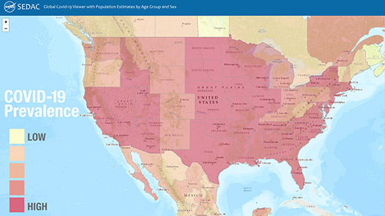
| The Global COVID-19 Viewer map from September 25 shows the prevalence of COVID-19 cases, defined as the total number of cases per 100,000 people, for the United States and parts of Canada and Mexico since early in the pandemic. |
The latest update to the Global COVID-19 Viewer: Population Estimates by Age Group and Sex features enhanced capabilities for visualizing the status and reach of the pandemic around the world, daily and over time since its beginning, and to identify at-risk populations. A pop-up trends graph illustrates daily and 7-day moving averages of COVID-19 cases and deaths for a range of select time scales—one month, three months, six months, and beyond. The graph may be accessed by simply clicking on a country. User-friendly mapping tools let users define a custom area or fly to a location of interest. Users may also easily move up or down administrative levels in many countries and view demographic and urbanization estimates relevant to possible risk factors for the virus. The Viewer was developed by the NASA Socioeconomic Data and Applications Center (SEDAC) managed by CIESIN. The underlying population data are from SEDAC′s Gridded Population of the World (GPW) Basic Demographic Characteristics, v4.11, for the year 2010, with estimates to 2020. The COVID-19 data are from Johns Hopkins University & Medicine Coronavirus Resource Center.
See: SEDAC Global COVID-19 Viewer
|
|
CIESIN Staff Participate in Virtual Meetings on Key Data Issues
|
|
September 24, 2020
During August and September, CIESIN scientists contributed to numerous online meetings and Webinars focused on diverse issues related to citizen science data, data quality and stewardship, geospatial data development and applications, and climate migration modeling and data. Senior digital archivist Robert Downs gave the presentation, “Improving Data Stewardship Based on the TRUST Principles for Digital Repositories,” at the #WeMissiPRES virtual meeting on 23 September. The annual International Conference on Digital Preservation (iPRES) was cancelled due to the COVID-19 pandemic, and was replaced by a virtual event consisting of three half-day sessions September 22–24. Downs′ presentation focused on the ongoing implementation of the TRUST Principles (transparency, responsibility, user focus, sustainability, and technology) at the NASA Socioeconomic Data and Applications Center (SEDAC) operated by CIESIN. Downs also presented, “NASA Socioeconomic Data and Applications Center (SEDAC): Current Status, Road Map and Challenges,″ during a virtual meeting of the World Data System (WDS) Harvestable Metadata Services (HMetS) Working Group on September 9. Alex de Sherbinin, associate director for Science Applications, gave the talk, “Data for the Sustainable Development Goals in Africa: The role of citizen-generated data,” at a Technical Validation Workshop on September 16 for the project, Standardizing City-Level Data-Gathering for Achieving Sustainable Development Goal 11 in Africa (SCiLeD). On 14 September, he also served as a panelist during the 2020 Global Shifts Colloquium, organized by the Perry World House at the University Pennsylvania, where he presented work on climate migration modeling and data sources. August 26–27 and September 4, CIESIN participated as an observer organization in the virtual Tenth Session of the United Nations Group of Experts on Global Geospatial Information Management (UN-GGIM). CIESIN′s delegation was led by director Robert Chen. The UN-GGIM promotes international collaboration on geospatial data and information and reports on all matters relating to geography, geospatial information, and related topics to the UN Economic and Social Council (ECOSOC). CIESIN has been a non-governmental organization with special consultative status recognized by ECOSOC since 1995. At the 2020 Earth Science Information Partners (ESIP) Summer Meeting Highlights Webinar on August 13, Robert Downs gave a lightning talk summarizing the ESIP Information Quality Cluster session, “Citizen Science and Data Quality.” The Webinar provided an overview of plenary and breakout sessions from the Summer Meeting, and is available for viewing on YouTube.
|
|
New Publications Released on Climate Risk, Citizen Science Data, Data Quality, and Boundary Data
|
|
September 19, 2020
Alex de Sherbinin, associate director for Science Applications, is guest editor of a special Issue of the journal Sustainability on climate risk and vulnerability mapping, with co-editor Stefan Kienberger of the University of Salzburg. He is also a co-author of one of the papers in the special issue, on using flood disaster data to validate components of social vulnerability to floods. The paper’s lead author is Earth Institute Fellow Beth Tellman. The article, “Still in Need of Norms: The State of the Data in Citizen Science,″ has been published in the journal Citizen Science: Theory and Practice. Anne Bowser of the Wilson Center is lead author, and de Sherbinin is a co-author. The article is a major output of the CODATA-World Data System (WDS) Task Group on Citizen Science and the Validation, Curation, and Management of Crowdsourced Data, which de Sherbinin co-chaired in 2016-2018. Senior digital archivist Robert Downs is a co-author of the report, “Laying the Groundwork for Developing International Community Guidelines to Effectively Share and Reuse Digital Data Quality Information—Case Statement, Workshop Summary Report, and Path Forward,” published in Open Science Foundation (OSF) Preprints. Ge Peng of the Earth Science Information Partners (ESIP) Information Quality Cluster is lead author. The report, which stems from a pre-workshop held in July 2020 prior to the ESIP Summer Meeting, describes the approach that will be taken to develop community guidelines for preparing and sharing data quality information. The Geo-Referenced Infrastructure and Demographic Data for Development (GRID3) program managed by CIESIN has released the white paper, “Harmonizing Subnational Boundaries,” on GRID3 efforts to support the harmonization, production, and use of digitized legal/administrative units, operational units, and statistical areas. This work addresses three primary areas: improving and harmonizing operational units; fostering improved collaboration on boundary harmonization among disparate government bodies; and using boundaries harmonization to support census efforts. The paper focuses on case studies in Nigeria, the Democratic Republic of the Congo, and Zambia.
See: Special Issue: “Climate Risk and Vulnerability Mapping″
Paper: “Using Disaster Outcomes to Validate Components of Social Vulnerability to Floods: Flood Deaths and Property Damage across the USA″
Paper: “Still in Need of Norms: The State of the Data in Citizen Science″
Report: “Laying the Groundwork for Developing International Community Guidelines to Share and Reuse Digital Data Quality Information—Case Statement, Workshop Summary Report, and Path Forward
White Paper: “Harmonizing Subnational Boundaries”
|
|
NASA Data Flows Even When the World Is Telecommuting
|
|
September 4, 2020
NASA recently published an article on its Earthdata web site about the continued flow of NASA Earth science data during the global COVID-19 pandemic. The article describes how the overall Earth Observing System Data and Information System (EOSDIS) was able to continue processing and distributing many terabytes of data each month even though NASA centers had closed and almost all staff had to shift to remote work. The article also highlights how two of the twelve NASA Distributed Active Archive Centers (DAACs)—the Alaska Satellite Facility DAAC operated by the University of Alaska, and the Socioeconomic Data and Applications Center (SEDAC) operated by CIESIN—have adapted to the changing work environment. CIESIN director Robert Chen, who has served as SEDAC's manager for more than 20 years, noted that this is not the first time that SEDAC has faced major disruptions (9/11 in 2001 and Superstorm Sandy in 2012). Among other efforts, SEDAC has worked to increase virtualization of its systems to strengthen flexibility and reliability. NASA recently exercised another option year in CIESIN's contract to continue operating SEDAC (through July 2021). CIESIN received an “exceptional″ performance rating from NASA for the option year that ended in July 2020.
See: Keeping NASA EOSDIS Data Flowing (Even When the World is Telecommuting)
|
|
New Earth Institute Fellow to Study Extreme Heat Events and Their Impacts
|
|
September 4, 2020
Cascade Tuholske has joined CIESIN for a two-year appointment as an Earth Institute postdoctoral research scientist. Tuholske is a geographer specializing in the integration of global-scale human and environment geospatial data to examine the relationship between urbanization and climate change. At CIESIN, he has begun working with director Robert Chen and associate director for Science Applications Alex de Sherbinin to construct a globally extensive, longitudinal, and fine-scale synthesis of extreme heat events, urban population growth, and the urban heat island effect. His goal is to inform adaptation strategies that reduce the harmful and inequitable impacts of urban exposure to extreme heat. He will also contribute to another NASA-funded project on the use of gridded population and settlement datasets to assess progress towards the United Nations Sustainable Development Goals (SDGs). Tuholske received his PhD in geography from the University of California, Santa Barbara, where he focused on the nexus of climate change, urbanization, and food security in Africa under the guidance of Prof. Kelly Caylor.
|
|
Bilingual Videos Provide Training on Integrating Spatial Data
|
|
August 25, 2020
The Population-Environment Research Network (PERN) has released several online training modules in English and Spanish on the fundamentals of spatial data integration, geared towards demographers and other population researchers. Developed by Susana Adamo, CIESIN research scientist, and Professor Landy Sanchez of the Center for Demographic, Urban, and Environmental Studies at El Colegio de Mexico (COLMEX), the video-based tutorials draw on pre-packaged data and open source geographic information system (GIS) and Web-based tools. The goals of the online training are to review the fundamentals of spatial data integration, with an emphasis on remote sensing; present an overview of relevant datasets and services (platforms and tools); develop basic skills for linking demographic and environmental data; and expand the use of specialized data sources. Production was supported by the International Union for the Scientific Study of Population (IUSSP) through a grant from the William and Flora Hewlett Foundation. PERN is a scientific panel of IUSSP and a sustained partner of Future Earth, and is hosted by the NASA Socioeconomic Data and Applications Center (SEDAC) managed by CIESIN. Adamo is co-coordinator of PERN and SEDAC′s lead project scientist; Sanchez is former chair of the PERN Scientific Committee.
See: bilingual training modules
|
|
Summer Brings More CIESIN Staff Changes
|
|
August 6, 2020
Data and program analyst Jolynn Schmidt has been promoted to program manager-data lead for CIESIN’s Geo-referenced Infrastructure and Demographic Data for Development (GRID3) program. The promotion recognizes her increased responsibilities for managing geographic information systems (GIS) activities and systems implementation with a growing team of GIS specialists. GRID3 is addressing challenging problems in a range of African countries, including new efforts driven by responses to the COVID-19 pandemic. Schmidt has a master of geographic information systems degree from Pennsylvania State University. Former student intern Juan Martinez has been hired as a research staff assistant in CIESIN’s Information Technology division, working with Kytt MacManus, senior systems analyst/GIS developer, on the development of nighttime lights data and mapping services. Martinez earned his BA in sustainable development from Columbia’s School of General Studies, after completing an AA in liberal arts from Borough of Manhattan Community College. Research staff assistant Rya Inman has accepted a teaching fellowship at Loyola University, where she will work towards a master′s in education. Inman has supported MacManus on a variety of CIESIN projects and served as his teaching assistant for several semesters. Inman graduated from the dual BA program between Columbia University and Sciences Po Paris, majoring in social sciences and earth science.
|
|
CIESIN Alumna Appointed Director of Institute for Demographic Research at City University of New York
|
|
August 4, 2020
Former CIESIN scientist Deborah Balk has assumed the directorship of the Institute for Demographic Research (IDR) at the City University of New York (CUNY). She had served as IDR′s associate director since 2006. Balk is also professor of public affairs at the Austin W. Marxe School of Public and International Affairs at Baruch College. She serves on several noteworthy committees, including the National Research Council (NRC) Committee on Population, the U.S. Census Bureau’s Scientific Advisory Committee, and the New York City Panel on Climate Change, for which she is a co-chair. She was an Andrew Carnegie Fellow 2016–2018. Her research focus is urbanization in the developing world, using a spatial framework to explore the demographic implications of climate-change issues. Balk is currently working with Kytt MacManus, senior systems analyst/GIS developer at CIESIN, and with Gordon McGranahan of the Institute of Development Studies in the United Kingdom, on updates to the low-elevation coastal zone estimates developed in a 2007 study. She was lead project scientist for the NASA Socioeconomic Data and Applications Center (SEDAC) operated by CIESIN from 1998 to 2006, spearheading the development of many widely-used population-related data products and services. She later served as a member of SEDAC′s User Working Group (UWG) 2015–2018.
|
|
Earth Institute Scientists Bring Climate Change Learning into the Classroom
|
|
July 31, 2020
Senior geographic information specialist Dara Mendeloff joined Earth Institute experts on climate and sustainability issues in a live online professional development event for K–12 educators sponsored by the Earth Institute July 28–29. The event, “E.I. Teach: Climate Change in the Classroom,” emphasized project-based learning, providing educators with the tools and content to address climate change in their classroom curricula using dynamic hands-on and interactive learning approaches. Mendeloff’s session, “Get the GIS of Climate Change,” demonstrated how educators can use geographic information system (GIS) tools available through the Esri cloud-based service ArcGIS Online, to analyze data on sea level rise, coastal flooding, and storm surge in New York City, gaining insight into the intersection of socioeconomic and climate issues. Other presenters at the event included Jason Smerdon, Nichole Anest, and Margie Turrin of the Lamont-Doherty Earth Observatory. The event was aimed at educators focused on grades 6–12 on the first day, and K-5 on the second day. Participants received a certificate following completion of the relevant workshop.
See: “EI Teach” for K-12 Educators
|
|
Symposium Offers Multi-Disciplinary Retrospective on Planetary Health
|
|
July 30, 2020
Established in 2011, the World Wide Human Geography Data (WWHGD) Working Group provides a platform for the discussion of human geography issues and sharing of human geography data. In recognition of its long track record of conferences and webinars, the WWHGD organized a 50th Retrospective Symposium on the topic of planetary health, an all-day online event on July 29 that brought together many of the experts who had presented at one or more prior WWHGD events. CIESIN associate director for Science Applications Alex de Sherbinin was invited to speak about climate and human geography in the session, “A Conversation on Environmental Change Impacts.” CIESIN director Robert Chen participated in the closing panel on strategic human geography perspectives and solutions for future challenges. The Symposium highlighted a diverse set of data and information resources related to human security and planetary health, including a number of data sets and tools provided by CIESIN through the NASA Socioeconomic Data and Applications Center (SEDAC) and other CIESIN projects. Co-led by the National Geospatial-Intelligence Agency and the US Department of State, the WWHGD Working Group has nearly 5,000 members spread across more than 150 countries.
|
|