
Programs and Projects
Major Programs
Notice: The contract for the CIESIN-managed NASA Socioeconomic Data and Applications Center (SEDAC) was terminated on 30 April 2025. SEDAC data along with recent CIESIN data releases are now available through the CIESIN Data page. You may also access SEDAC data sets through the NASA Earthdata Human Dimensions page. For further information please contact [email protected].
CIESIN managed the NASA Socioeconomic Data and Applications Center (SEDAC) from 1998-2025. SEDAC data sets are in formats that promote interdisciplinary research and applications. SEDAC data facilitate interdisciplinary research between the physical sciences and the social sciences with the goal of enabling greater public understanding of the impacts of global change. SEDAC data play a key role in the realization of societal benefits derived from the NASA Earth Science Division’s rich portfolio of space and air-borne observatories and instruments.
The Socioeconomic Data Distribution Centre (DDC) is operated under the auspices of the IPCC’s Task Group on Data (TG-Data) with funding from the NASA SEDAC. The purpose is to provide access to baseline and scenario data related to population, economic development, technology and natural resources for use in climate impact assessments. This information, along with environmental data and scenarios also held by the DDC, is important for characterizing the vulnerability and adaptive capacity of social and economic systems in relation to climate change in different regions.
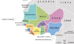
GRID3 works with government partners in the Democratic Republic of the Congo and Nigeria to make better use of geospatial data solutions in healthcare, education, and other sectors. GRID3 supports government efforts to blend conventionally collected official data with new data that is generated by novel approaches. To that end GRID3 uses advanced data science and technology, participatory mapping, satellite imagery and other innovations. As one of GRID3’s technical partners, CIESIN develops methodologies and tools for settlement and infrastructure mapping as well as automated pipelines for geospatial data products and cartographic representation.
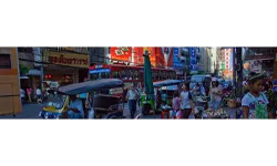
The EPI is produced every two years since 2006 by a research team from the Yale Center for Environmental Law and Policy (YCELP) and CIESIN, Columbia University. It utilizes a proximity-to-target methodology focused on a core set of environmental outcomes linked to policy goals. The index ranks country performance on high-priority environmental issues in three broad policy areas, protection of human health from environmental harm, ecosystem vitality, and climate change mitigation. The 2024 EPI uses 58 performance indicators to compare 180 countries.
.
PERN is an internet-based network with a membership of more than 2,100 researchers worldwide. Its mission is to facilitate scientific analysis and dialogue about population-environment relationships. PERN was launched in 2001 by the International Union for the Scientific Study of Population (IUSSP). Currently, it is a scientific panel of the IUSSP and a sustained partner of Future Earth, a global network of scientists, researchers, and innovators collaborating for a more sustainable planet.
The POPGRID Data Collaborative brings together the international community of data providers, users, and sponsors concerned with producing georeferenced data on population, human settlements, and infrastructure. The program seeks to improve data access, timeliness, consistency, and utility; support data use and interpretation; identify and address pressing user needs; reduce duplication and user confusion; and encourage innovation and cross-disciplinary use. It brings expertise and perspectives from diverse natural, social, health, and engineering science disciplines and sectors, and from government, academia, private industry, and nongovernmental organizations.
Open Data and Science
This project will help kick off NASA’s Transform to Open Science (TOPS) initiative. The project will develop online curricula to educate scientists at multiple career levels. The new SCHOOL lessons will be structured around the data science life cycle using open, interactive, earth science applications use cases that span the disciplinary areas of water resources, agriculture, health and air quality, disasters, climate, wildfires, and environmental justice, with the areas of population and infrastructure integrated into each. Instruction will involve accessing and analyzing NASA data sources in Open Data Science lifecycle workflows, drawing heavily on data and services from the twelve NASA Distributed Active Archive Centers (DAACs).
CIESIN partnered with ISciences LLC and Case Consulting International to develop DANTE, an open source software toolkit for systematic monitoring, forecasting, and analysis of environmental stressors and their impacts on security. Supported by the U.S. Army Engineer Research and Development Center (ERDC), DANTE is focusing on the role of environmental stressors in three key areas: international migration and refugee flows; internal migration and isolated populations; and conflict and political instability. The tools are being designed to accelerate quantitative interdisciplinary analysis of environmental stressors, taking into account demographics, economics, health, conflict, hazards, and other factors.
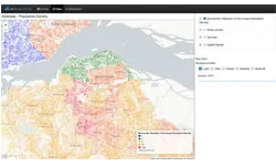
A joint effort between Meta and CIESIN, this project deploys high-resolution satellite imagery in conjunction with CIESIN’s Gridded Population of the World (GPW) to develop high resolution gridded population distributions, providing unprecedented levels of detail, especially for rural areas. The population grids provide detailed delineation of settlements in both urban and rural areas, which is useful for many research areas - from disaster response and humanitarian planning to the development of communications infrastructure and delivery of social services.
The Population and Infrastructure on Our Human Planet sought to support sustainable development through improved spatial data and models for human settlements, infrastructure, and population distribution based on Earth Observations. It included partners from the University of Louisville, ImageCat Inc., NASA Goddard Space Flight Center, and Baruch College. The project was part of NASA’s support of the Human Planet Initiative of the Group on Earth Observations (GEO). The project team worked with national statistical offices, government agencies and universities in Nigeria and Colombia to better utilize population and related data in sustainable development monitoring and decision making.

CIESIN has collaborated with the Department of Earth, Environmental, and Geospatial Sciences (DEEGS) at Lehman College of the City University of New York in the use of machine learning methods to develop and enhance data on the exposure and vulnerability of buildings and other infrastructure to hazards, working initially with five Lehman graduate and undergraduate students. This project extends recent work for the State of New York supported by the New York State Energy Research and Development Authority (NYSERDA). Application of the data to flash flood hazard assessment is also a project component, in concert with the International Research Institute for Climate and Society (IRI).

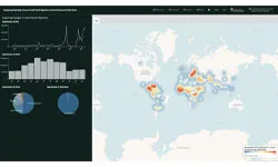
NASA's Socioeconomic Data and Applications Center (SEDAC), in collaboration with NASA's Transform to Open Science (TOPS) initiative, hosted an open science workshop for the community researching human-environment interactions. Held at the Lamont Campus of Columbia University on January 9, 2024, the workshop brought together 65 scientists from many disciplines with an interest in how to apply open science approaches to the highly interdisciplinary study of the human aspects of global environmental change. Open science is a movement that includes producing open data, using open-source software tools, publishing computer code openly, and publishing research in open access journals.
Climate Mobility
CIESIN leads the Columbia Climate School’s Climate Mobility Network, a network of researchers, educators, and law and policy practitioners across the social, physical and health sciences. The term climate mobility refers to voluntary and forced migrations that are influenced by climate variability and change, including migration as adaptation, internal displacement, refugee flows, managed retreat, and planned relocation. The network works to build capacity to teach, think, and develop policy about climate mobility. After three years of activities (2020-2023), the Network joined forces with the UN Global Centre for Climate Mobility (GCCM) to create a Knowledge Hub, and continues to support the Columbia Global Center’s Committee on Forced Migration.
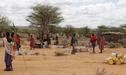
From 2021-2022, under a project of the Global Centre for Climate Mobility (GCCM), in association with the African Union Commission, the UN Development Programme, and the World Bank, with support from the Robert Bosch Foundation, CIESIN led modeling work to project the number of internal and cross-border migrants in Africa out to 2050 under different climate and socioeconomic scenarios (RCPs and SSPs). The results are presented in the report, Voices from the Frontlines. This work built on CIESIN’s pioneering work for the World Bank’s Groundswell report series described below.

Under a project of the Global Centre for Climate Mobility (GCCM), in association with the Association of Caribbean States, the International Organization for Migration, the UN Development Programme, and the World Bank, CIESIN is contributing to modeling work to project the number of internal and cross-border migrants in the greater Caribbean basin out to 2050. It has also conducted a literature review exploring the evidence for climate-related mobility in the basin - from direct displacement by major hazards such as hurricanes to longer term movements related to the economic impacts of climate change.
In 2021 CIESIN began a three-year collaboration with Oregon State University funded by the DOD Minerva Research Initiative comparing underlying drivers of international migration flows from Central America and West Africa to the US and Europe, respectively. Increased understanding of these dynamics will help improve policy responses to the humanitarian and security challenges posed by migration crises. The team are employing innovative methods to answer two questions: 1) To what degree do climate factors contribute to migration flows, versus individual, structural, and governance factors? 2) How may such flows change in response to combined changes in social, political, economic and climate factors? The Columbia team also includes scientists at the Center for Climate Systems Research (CCSR) and the Lamont-Doherty Earth Observatory.
From 2019 to 2023, CIESIN teamed with scientists at Columbia’s Lamont-Doherty Earth Observatory, The School of International and Public Affairs (SIPA), and the Center for Climate Systems Research (CCSR), together with scientists at New York University, on a grant from the National Science Foundation (NSF) to integrate climate science, crop modeling, geography, economics and political science in the study and prediction of migration within and out of West Africa. This trans-disciplinary approach aimed to increase understanding of the convergence of complex factors that influence migration, from climate and environmental influences to changing political, social, economic and demographic conditions, locally and globally.
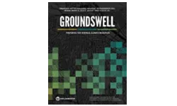
From 2017 to 2022, CIESIN partnered with the World Bank, The City University of New York (CUNY) Institute for Demographic Research (CIDR), and the Potsdam Institute for Climate Impact Research (PIK) to produce a series of reports: Groundswell, Groundswell II, and two regional reports for Africa (Lake Victoria and West Africa). Deploying the CIDR INCLUDE population gravity model, the research team projected future population distributions and migration under climate scenarios and development-only scenarios, with a focus on climate impacts that could affect livelihoods in low income countries: projected changes to water availability and crop production as well as sea level rise. Groundswell Africa incorporated additional impacts and variables, such as flood risk and conflict incidence.
Climate Assessment

This five-year, $48.9 million dollar project funded by the US Agency for International Development (USAID) addressed direct and indirect drivers of natural resource degradation to improve livelihoods and natural ecosystems across the West Africa region. The project worked with partners at the community, national, and regional levels, including the Economic Community of West African States (ECOWAS) and the Manu River Union (MRU), to strengthen policies and systems that will improve natural resource management and the health and resilience of selected coastal and upland forest ecosystems. The project was divided into three components: combating wildlife trafficking, building coastal climate resilience, and improving forest conservation through a landscape approach. As an implementing partner, CIESIN contributed to the last two components through coastal vulnerability assessment, climate information for adaptation, and remote sensing analysis for forest carbon assessment.

The USAID Climate Adaptation Support Activity (CASA) provides strategic support to USAID Missions and USAID/Washington to advance effective adaptation mainstreaming, programming, and scaling meaningful change. Climate change affects virtually everything USAID does. It also threatens the development progress the Agency has supported for more than 60 years. To counter this, USAID has been working to help communities prepare for and manage climate impacts while also protecting and advancing critical development priorities. USAID’s adaptation initiatives support climate information, research, planning and policy, technology, and best practices across a range of sectors. In doing so, they advance global food and water security, reduce impacts of climate-related shocks and stresses, prevent the spread of vector-borne disease, and reduce conflict. CIESIN developed the methodology for the CASA Urban Landscape Assessment to assess the degree of climate risk for cities in all USAID countries.
Geospatial Support
Since 2016 CIESIN has supported the SERVIR regional hub in West Africa, one of the regional hubs of a joint initiative of NASA and USAID in low and middle income countries to support the use of satellite data for economic development and environmental protection. Currently, CIESIN is part of a team led by the International Crops Research Institute for the Semi-Arid Tropics (ICRISAT) to implement phase II of the hub. CIESIN’s work includes geospatial technical support, socioeconomic data integration and analysis for regional services, and capacity building in the area of data management.
Under the NASA Headquarters Applied Sciences Program (recently renamed Earth Action), CIESIN is working with NASA scientists and the global development organization Mercy Corps to apply remote sensing and other geospatial data to complex humanitarian situations.
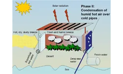
CIESIN supported the GIS-Based Graphical User Interface Tools for Analyzing Solar-Thermal Desalination Systems and High-Potential Implementation Regions project in 2021-2022 (Resources for Solar Desalination), with funding by the United States Department of Energy. Led by the Columbia Center for Life Cycle Analysis (CLCA), the project used state-of-the-art solar-thermal desalination models to develop software that supports the planning and valuation of solar-thermal and hybrid technologies. CIESIN contributed to the integration of spatial data and geographic system functions with the desalination models.