CIESIN Thematic Guides
 A proposal for a global 1-km Advanced Very High Resolution Radiometer (AVHRR) database was developed by the Land Cover Working Group of the International Geosphere-Biosphere Program's Data and Information System (IGBP-DIS), as described in the report Improved Global Data for Land Applications (Townshend 1992). The proposal advocates the development of the database to meet a number of requirements of the IGBP science program and outlines how, given the large logistical effort of acquiring AVHRR 1.1-km source data on a global scale, such a database could be created.
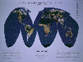
Development of the database is in progress. Daily global AVHRR 1.1-km data are being acquired from numerous AVHRR ground reception stations and through judicious use of the tape-recorder on-board the satellite. The effort, coordinated by IGBP-DIS, includes the participation of the U.S. Geological Survey's Earth Resources Observation Systems Data Center (EDC), the U.S. National Aeronautics and Space Administration (NASA), the U.S. National Oceanic and Atmospheric Administration (NOAA), and the European Space Agency (ESA). All data are being sent to EDC for archiving and production of the database. Currently, plans call for EDC to develop a 12-month time series of 10-day maximum Normalized Difference Vegetation Index (NDVI) composited data sets by November 1994. The 12-month time series will cover the period of April 1,1992, to March 31, 1993. Figure 1 shows a prototype image of the global 1-km AVHRR data base. Longer term planning may extend the length of the composited data set production to a period of 30 months.